prepared by Bob Diaz for: Professor Reid Gomez’s class titled, “Gender, Identity and Power” (GWS 200-001), March 17 and 24, 2026.
Introduction:
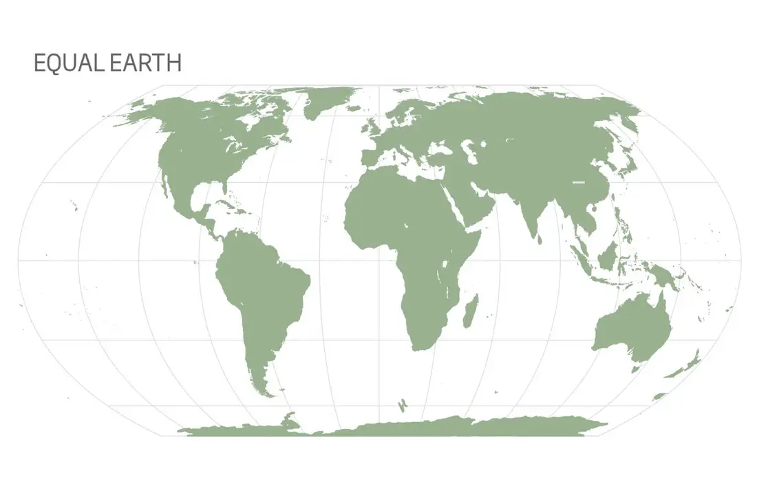
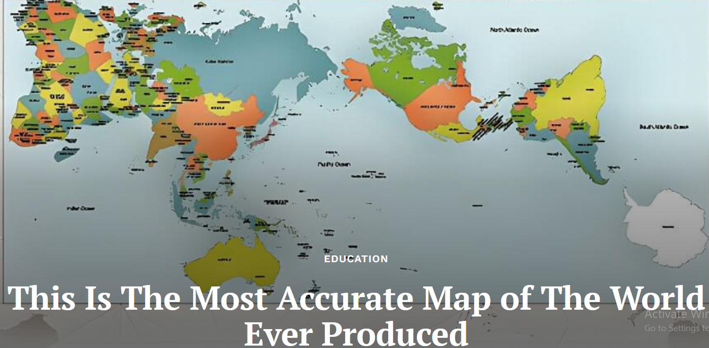
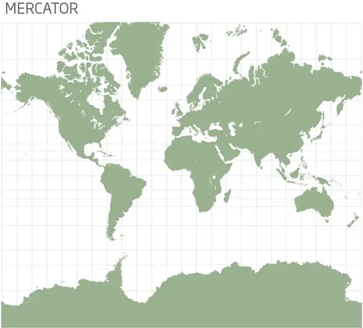
“In his classic essay, “Deconstructing the Map”(Cartographica v. 26, no.2 Spring 1989), Professor J. B. Harley argued that despite claims to objectivity and pure science, cartography always has a hidden agenda. “Sometimes agents of change, [maps] can equally become conservative documents. But in either case, the map is never neutral.” Though map consumers and even mapmakers themselves seldom realize it, Harley observed, maps reflect social hierarchies and cultural norms. Every map was made by someone who decided what to include, omit, or prioritize; those editorial choices were consciously or subconsciously influenced by social conditioning”– Michael Taylor, curator of books, Louisiana State University Library.
As we proceed with today’s class and exercises, please keep this statement in the back of your mind. When we wrap up today, we’ll come back to this statement and discuss it again.
About the UA Libraries:
Main and branch libraries. Including Health Sciences, Science-Engineering, and Special Collections. The UA Library began early on in the life of the UA, in the early 1880s. Special Collections as a separate department within the UA Library system, started in mid-50s. We have always collected rare materials, particularly about Arizona.
The UA catalog can be found here: https://lib.arizona.edu/
About Special Collections page: https://lib.arizona.edu/special-collections
How to use special collections https://lib.arizona.edu/special-collections/about/how-to-use
When you visit Special Collections, be prepared to present a list of materials (preferably with call numbers) to the desk staff. It’s critical to do your homework before you visit. If you do need assistance finding materials, we will gladly help you. You will be asked to follow some basic procedures for handling our materials. You will be asked to wash your hands, to put away your belongings etc. We will share our other guidelines with you at point of need.
Who, what when where why and how of Special Collections: Librarians, archivists, digitization specialists work together to take care of rare books, acquire and catalog manuscript collections, serve the public by providing both digital and physical access to materials, reference service, and instruction. We also create exhibitions and sponsor public programming and we are open to the public, Monday through Friday throughout the year (except most major holidays).
Preserving rare and unique materials and making them available to the public helps to add to the cultural wealth of a State or region. This type of material is the stuff of history, and is available to anyone for viewing and studying, free of charge.
Our strengths. Borderlands, literature, mining, ranching, performing arts, UA history.
Unique collections that bring a lot of attention to us: USS Arizona collection, American Vaudeville Museum collection, Stewart Udall papers, Mo Udall Papers, Up With People collection, Sophie Treadwell papers, Edward Abbey papers, Charles Bukowski papers. Artists books. James McDonald collection (UFO materials). Books on the history of science. History of the University of Arizona.
Using our materials.
Maps, books, journals, newspapers, can be found using the UA catalog. https://lib.arizona.edu/
Use an index to find collection guides. You have to use a separate set of tools to find manuscript materials. The online catalog does not cover the vast majority of manuscript collections.
Arizona Archives Online, http://azarchivesonline.org/xtf/search
Archivesspace https://archives.library.arizona.edu/
How do I search for maps?
Use library search to find maps.
- Type your keywords in the search box.
- Under “Material Type,” select “Maps.
- Select Apply Filters at the bottom of the page.
Include keywords for both the geographic region and the type of map (e.g. topographic map, geologic map, road map) you need.
Examples:
*Mexico vegetation maps
*Arizona physical maps
*New Mexico topographic maps
* Pima County remote sensing maps
Basic Map literacy:
Maps are symbolic, scaled-down, flat representations of geographic areas, featuring essential elements like titles, legends, scales, and compass roses to aid interpretation. Key types include political (boundaries), physical (terrain), and thematic (specific data) maps. They are crucial for navigation, measuring distance, and visualizing spatial data.
Essential Map Components to Know
- Map Title: Tells you exactly what area or subject the map is showing.
- Legend/Key: Decodes symbols, colors, and lines used on the map.
- Scale: Indicates the relationship between distance on the map and actual distance on the ground (e.g., 1 inch = 1 mile).
- Compass Rose/North Arrow: Shows orientation (North, South, East, West).
- Grid System (Latitude/Longitude): Imaginary lines that help pinpoint exact locations.
- Labels: Identify locations, cities, and physical features.
Main Types of Maps
- Physical Maps: Highlight natural features like mountains, rivers, and oceans.
- Political Maps: Show man-made features such as borders, cities, and states.
- Thematic Maps: Focus on a specific theme, such as climate, population density, or economic activity.
- Topographic Maps: Detailed, scale-model representations of terrain elevation.
Class exercise.
Pick two to three maps and an atlas and compare and contrast them. Note down the pertinent information about the map using the above definitions. What is unique about each map? Think about the statement made at the beginning of the class. Were there any issues that arose for you related to map making and issues of power and privilege?
Additional Online Collections
Library of Congress, American Memory Project — https://www.loc.gov/maps/collections/
David Rumsey Collection — http://www.davidrumsey.com/
American Geographical Society Online Maps and Photos — https://uwm.edu/lib-collections/agsl-digital-map-collection/
New York Public Library Map Collection — https://digitalcollections.nypl.org/collections/lane/maps-atlases
Sanborn Fire Insurance Maps — https://www.loc.gov/collections/sanborn-maps/about-this-collection/
University of Texas Austin Map Collection Historical Maps — https://www.lib.utexas.edu/maps/historical/